April on Ben Lomond
Back to home pageIt was a bright sunny spring day in early April, 2007. The forecast was for a cooler north wind later in the day, but that didn't materialize before dark. It was a beautiful day to be walking a hill.
Below are some photos with a narrative in the captions beneath each photo.
Click on a smaller image below to see a larger version of the picture. When viewing a larger picture, clicking "Next" allows you to look at the larger pictures one at a time.
Even the larger versions of these images are not of sufficient resolution for a quality print. If you would like a higher resolution printable picture, please let me know.

Starting off from the bank of Loch Lomond, which is less than 50 feet above sea level. We had driven to the end of the road along the east side of the loch. The car was parked about 100 yards behind where I took this photo looking up the loch.

Our initial ascent is the brown slope directly above the sign. Then the path goes off to the left beneath the top of the ridge.

The hills on the other side of the Loch Lomond near Arrochar come into view to the northwest.
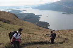
This is the way to walk up a hill -- stopping frequently to admire the scenery below and noticing the path already ascended.

Continuing up the path, it crosses the small burn. The first glimpse of the top of Ben Lomond is barely visible ahead.

Our lunchroom is on a sunny hillside, with a view of Loch Lomond and the islands in the lower portion of the loch. The hills beyond Arrochar are off to our right.

At this moment the walkers are not looking back down the hill to relish how far they have come. Instead they are looking up at the upper slopes of Ben Lomond.

Looking at the southwest face of Ben Lomond it looks intimidating. The path we are on ascends the ridge line on the left side of the hill. I don't think the resolution of this photo is sufficient to see that there are at least a half dozen people on the top of Ben Lomond.

The top of Ptarmigan Ridge is quite flat, so I went to the northwest edge to take a few pictures of the hills in the distance. The hills are, from left to right, Ben Donich, Ben Arthur, Ben Luibhean, Ben Narnain, Ben Ime and A' Chrois. They are six to eight miles away. Along the shore of Loch Lomond is the village of Tarbet. Across the low isthmus is the village of Arrochar and Loch Long (a tidal salt water finger of the sea).

The endless hills to the north.

This shows the remaining ascent of Ben Lomond. It looks like my two walking companions are waiting for me to finish wandering around taking pictures. Two other walkers have just gone past them on their way down the hill.

On the top another walker snapped this photo of us standing beside the concrete survey marker. The altitude is 3200 feet.

This view is looking south from near the top at the broad main path down the gentle ridge line.

The shadows are getting long toward the end of the day. Ben Lomond is behind us as we descend. These walkers appear happy, probably because of the beautiful weather and the fact that it is all down hill from here.
The GPS receiver plotted the route walked. It also recorded the distance travelled as 8.5 miles. Each time I left the main path to snap a photo, the GPS receiver recorded that excursion. To view the map in a new window click on the following link: Map of Ben Lomond walk. It may take a a few seconds to download the map. Zooming in shows the green line of the route walked. It deviates off to the side when I wandered. The longest side excursion is at the northwest extent of the walk where I went out onto the rather flat hilltop while my walking companions stayed on the main path. The scroll and zoom features of your web browser can be used to see the map in more or less detail.
For some more photos of Ben Lomond, click this link: More Ben Lomond Photos
Back to home page