Big Bend National Park in February 2010
|
Back to home page
|
In February 2010 we spent three days in Big Bend National Park along the Mexican border in West Texas.
Below are some pictures with a narrative beside each one. Click on an image below to see a larger version of the picture. When viewing a larger picture, clicking "Next" allows you to look at the larger pictures one at a time.
|

|
It is a 500 mile drive to Big Bend National Park, which is one of the reasons that I have never had a chance to visit it. There was finally an opportunity, an international visitor being the excuse. On Friday, 12 February 2010, we drove from Fort Stockton and Marathon to the North Entrance to the Park. This route is across a relatively flat desert with a few features in the distance, as in this picture.
|
|

|
Then a large cluster of hills appeared on the horizon, called the Chisos Mountains. In the park visitor information center we learned that the mountains are a much eroded cluster of rather ancient volcanos. The diameter of the cluster is roughly ten miles.
|
|

|
This closer view of the west side of the ancient volcano shows that the outer slope is rather steep and rugged, rising sharply from the fairly flat desert floor. The path on the lower right of this picture leads to the site of an early 20th century ranch.
|
|

|
This is the remnant of the largest remaining wall of the adobe ranch house. How someone could earn a living in such a dry area isn't clear.
|
|

|
There are two wind-driven wells near the ranch house. This one is fully functional, producing a steady trickle of water that is keeping several trees alive that could not survive without this man-made support. Presumably the Park Service has restored the windmill and kept it repaired.
|
|

|
On the other hand, the other windmill hasn't pumped any water in many decades.
|
|

|
Desert brush and cactus against a backdrop of almost vegetation-free hills.
|
|

|
A canyon eroded into the desert floor.
|
|

|
The symmetry of this hill is striking. The grey gravely rock in the foreground is ancient volcanic ash.
|
|

|
I'm not sure why there is pink cactus in this desert, but we saw quite a few. The two and three inch thorns sure are intimidating.
|
|

|
Another strikingly symmetrical hill, this one down near the Rio Grande.
|
|

|
This is looking into the mouth of Santa Elena Canyon. The water is the Rio Grande. The left wall of the canyon is Mexico and the right wall is in the United States. We walked a few hundred yards up the canyon on the path visible in the bottom center.
|
|

|
This view is looking out the mouth of Santa Elena Canyon. The steep cliff on the Mexican side of the border is throwing a rather long shadow across the river. The Rio Grande is flowing from the bottom right in this picture around the visible bend to the center right. There are a couple of people standing on the sand bar beside the rapids at the lower center of this picture. The river appeared to be about knee-deep at that point.
|
|

|
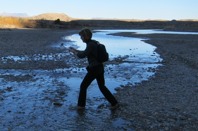
This picture is attempting to depict an "alien" crossing the Rio Grande.
|
|
|
And here is another "alien" rushing across the river. However, it is actually Terlingua Creek that the "aliens" are crossing, about a hundred yards upstream from where it flows into the Rio Grande.
|
|

|
The next day we hiked from the parking lot in the Chisos Basin to the South Rim via the Pinnacles and Boot Canyon Trails. We knew it would be a long walk, so fortunately we were able to get started fairly early. The sun was not yet high enough in the sky to reach into the Basin. The temperature was chilly, but climbing up the trail warmed us up nicely. The trail was very well constructed. It was a steady climb, but at no place was it steep. The two sisters so enjoy interesting plants, a topic on which I have little to contribute.
|
|

|
The biggest surprise of Big Bend was that the inner slopes are forested. I did not expect to see so much green in the desert. This view is looking north down to where we had left the car.
|
|

|
The large formation of the Casa Grande Peak was a dominant sight for the first hour of our hike.
|
|

|
A view from a bit higher of Casa Grande Peak.
|
|

|
This view appealed to my eye, framed by nearby trees.
|
|

|
Out of the sun on this north-facing slope, there was a little bit of snow still on the ground from a storm a few days earlier.
|
|

|
This is a view westward, out through the gap through which the stream that drains the Basin flows. The relatively flat desert beyond is seen through the gap.
|
|

|
After the initial upward slope, the path leveled out for most of the rest of the day. It was a very pleasant walk on an excellent trail. We chose not to climb to the highest point in the Park, Emory Peak. We figured making it to the South Rim and back would be more than enough for the day.
|
|

|
This view is looking eastward down through Boot Canyon to the desert beyond.
|
|

|
It is called Boot Canyon because the pinnacle on the right looks like an upside-down cowboy boot.
|
|

|
It didn't seem like we were walking in a desert, with so many green trees and even a stream beside the path flowing from one pool of clear water to the next rock pool.
|
|

|
I can't get enough of the blue sky and green trees in the desert. It is February, so it is too early in the year for the grass to be green. People say that Big Bend has good wildflower displays in the spring following a rain.
|
|

|
When we reached the South Rim the contrast between the surprisingly green foliage we had walked through and the stark desert beyond became graphically clear. There was a steep drop and the green trees stopped abruptly. The higher altitude and the protection of the surrounding peaks forms a different environment from the surrounding lower altitude desert.
|
|

|
The view from the rim looking south is across 15 miles of desert down to the Rio Grande river. The high cliffs in the distance are in Mexico. The Park Service says the haze is due to two large electric power plants in that remote section of Mexico that do not have emission prevention.
|
|
|
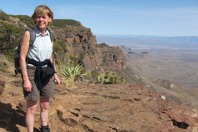
We took pictures of each other at our South Rim destination.
|
|

|
There were a few other hikers that passed by, but we neglected to ask one of them to take a picture of the three of us. After these pictures at our destination, we sat down for some lunch -- another lunchroom with a view.
|
|

|
The view from the rim to the southwest is more rugged. We can't remember for sure from the geologic description, but we think that cluster of lower hills is the result of lava flow.
|
|

|
This is along our return walk on the Laguna Meadow Trail. All of the trails we walked have been excellently maintained.
|
|

|
That is the highest peak in Big Bend National Park, Emory Peak. Our morning walk was around the east side of it and in the afternoon we passed below that cliff on the west side of the peak.
|
|

|
This is a view to the southwest, down Blue Creek Canyon I believe.
|
|

|
Here we are on a gently descending trail below Emory Peak.
|
|

|
Looking up at Emory Peak.
|
|

|
We reached this overlook. We could see where the car was parked in the Chisos Basin (the left center in this photo). However, because our feet were tired, it seemed to take a very long time to get there. The path was at no place steep because the trail followed a zigzag route when needed.
|
|

|
Because the sun was low in the western sky, the light was dull within the Basin, so this was the last photo snapped. The trail can be seen in the lower right of this picture. It was well into dusk when our tired feet got us back to the car. According to the guidebook, we walked 12.6 miles, but my tired feet felt we had gone 20 miles.
|
|

|
The next afternoon we went on a shorter walk. The Lost Mine Trail is five miles up and back to the car. It starts at the pass (the highest point) along the road into the Chisos Basin.
|
|

|
This is Casa Grande Peak, from the north, the same hill we had seen from the other side the previous day.
|
|

|
This view is looking west, through the road pass into the Chisos Basin. The distant hill is the ridge on the north wall of the Basin.
|
|

|
This view is looking south, past Casa Grande toward other peaks along the east rim.
|
|

|
Looking upward the slope is steep, but the path zigzags to provide a gentle walking ascent.
|
|

|
This is another view through the pass into the Chisos Basin.
|
|

|
The top of the ridge is largely bare rock with interesting rock outcrops.
|
|

|
There are several pinnacle rocks in the foreground with Casa Grande in the distance. Snapping photos into the sun takes away the blue in the sky.
|
|

|
Another pinnacle.
|
|

|
Flat rocks that are easy to walk on, pinnacle rocks and trees growing in the cracks.
|
|

|
Standing on a rock looking at all of the other rock formations ahead. We didn't have time to walk further down the ridge.
|
|

|
Walking back down the well designed and maintained path.
|
|

|
Near the car the setting sun is lighting up the hills.
|
|

|
Another rock formation lit up by the setting sun.
|
|

|
It happened to be Presidents Day holiday weekend, so the Lodge in the Chisos Basin was fully occupied. We stayed in this cabin eight or ten miles outside of the West Entrance to the Park.
|
|

|
This is the backdrop to the cabin looking up from the highway.
|
|

|
This view is looking from out cabin toward the highway heading north to Alpine. The woman who lives in the building with the white roof rents half a dozen similar cabins and mobile homes. The name of the business is Wildhorse Station.
|
|

|
Looking down the highway toward the towns of Study Butte and Terlingua. I'm not sure either town is organized enough to have any of the public services normally offered by a town.
|
|

|
We didn't come away with many photos of Terlingua. It seems to be occupied by an odd mixture of characters. It was a mining town a hundred years ago, mining cinnabar, the ore from which mercury is extracted. It was then an abandoned ghost town for decades until the hippies began settling in the area. The place in this photo seems to be an attempt to catch the attention of passing tourists -- a rough semblance of a nuclear submarine conning tower, a wooden sailing ship, a statue of liberty, etc. We had a meal at a nearby restaurant. The waitress and owner were different but fun.
|
|

|
This is the hippy corner of Terlingua Cemetery.
|
|
|
|
Back to home page
|