Touring New England
|
Back to home page
|
In June 2008 we toured New England. We saw and did a lot but there were also many things we didn't have time to see.
Below are some pictures with a narrative beside each one. Click on an image below to see a larger version of the picture. When viewing a larger picture, clicking "Next" allows you to look at the larger pictures one at a time.
|

|
This was the tour bus, for a total of six people, with a trailer for luggage.
|
|

|
One day someone took a picture of the bus driver loading the baggage.
|
|
|
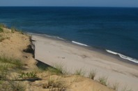
The beach on the east side of Cape Cod looks like this for miles. Winter storms take an average of three feet off of the sand cliff every year, as has apparently occurred since the last ice age.
On this sand dune Marconi, a radio pioneer, built in 1901 a two-way radio station to communicate with ships in the North Atlantic as well as a similar station at Poldhu, Cornwall, Britain (we were at the that Cornish cliff-top a year ago).
|
|

|
The replica of the Mayflower is in harbor of Plymouth, Massachusetts. In the autumn of 1620 the Mayflower anchored here with the families that became the first English-speaking permanent settlers north of Virginia.
|
|

|
Some years later a rock on the beach was engraved with the date: 1620. However, on the day we were there, all we could see of Plymouth Rock through the scaffolding was the side away from the date.
|
|

|
There is an excellent reconstruction of the original settlement, called Plimouth Plantation. This view is looking down the main road toward Cape Cod Bay.
|
|

|
This view is looking up the same road.
|
|

|
There are actors in seventeenth century costumes who speak with tourist visitors in the language of the early 1600s and answer questions about their colony and their activities.
|
|

|
I spoke for a while with this fellow about his work as the blacksmith of the colony.
|
|

|
This lady spoke optimistically of their food production, expansion of the colony, and their relationship with the local Indians.
|
|

|
There is also a replica of an Indian village of the 1620s. Their hut is made of bark from large trees.
|
|

|
The Indians in the village talk with tourists about the seventeenth century Indians but in the language of today.
|
|

|
This is a boardwalk across the sand dunes down to the beach of Cape Cod Bay.
|
|

|
Everyone enjoyed a fresh seafood dinner.
|
|

|
The next day we took the ferry from Hyannisport to Nantucket Island. We were told that several of those luxury homes along the shore belong to the Kennedys. At that time Senator Ted Kennedy was probably there recuperating from recent surgery.
|
|

|
Someone took this picture of an old man looking serenely out to sea. With the camera ready, I suspect the old man was waiting to take the next photo.
|
|

|
This view of the Kennedy compound is from the outside of the breakwater that protects the anchored boats in the previous picture of the Kennedy site.
|
|

|
Entering Nantucket harbor.
|
|

|
Another view of Nantucket harbor.
|
|

|
The oldest house on Nantucket.
|
|

|
Before electricity, power was available from the wind off the sea.
|
|

|
Nantucket Lighthouse
|
|

|
The next day we took the train to Boston, to avoid rush hour traffic and parking hassles. This picture was taken on a Boston street.
|
|

|
This is a view of downtown Boston from a harbor tour boat.
|
|

|
We toured Old Ironsides, a 200-year-old US Navy ship. It is in the process of significant restoration, which is why the upper masts are removed.
|
|

|
After lunch there was a heavy rain storm. We took shelter in the lobby of a Navy Yard office. The rain lasted perhaps 45 minutes and it was dry for the rest of the day.
|
|

|
The contrast of a colonial (eighteenth century) building surrounded by twentieth century buildings is fun to see. This is the Old State House. It normally has a distinctive tower and dome but that was covered in scaffolding when we were there.
|
|

|
Across the street is Faneuil Hall. It was originally built as a public meeting hall above a public market. The building was enlarged in the early 1800s and still serves today as a public meeting hall with sales stalls on the ground floor.
|
|

|
On the other side of Faneuil Hall, two talented street performers were putting on a show.
|
|

|
This is the home of Paul Revere. He was an accomplished silversmith, who made things of other metals too, including large bells. He was one of several who in 1775 rode through the night to warn patriots that the British Army was on the way to destroy stored arms.
|
|

|
It was from the tower of Old North Church that lantern lights told Paul Revere and the other riders to spread the warning.
|
|

|
This is a colonial era cemetery two blocks from Old North Church.
|
|

|
The next day we drove to Concord, the location of the first battle of the American Revolution. The British Army reached this bridge and were confronted by an armed militia force.
|
|

|
The statue on the other side of the bridge depicts a farmer who is leaving his plow with his rifle in his hand.
|
|

|
The militia of farmers were called the Minutemen because on a minutes notice they would pick up their weapons and go to the village green to serve with their neighbors. This is another Minuteman statue on Lexington Green. As Minutemen from villages further away converged on the British Army retreat route, there were quite a few additional skirmishes for much of the way back to Boston.
|
|

|
The next day we went to a Shaker village in New Hampshire. The Shakers were a late 1700s spin-off of the Quakers. They formed several communal villages in New England and New York, and then in the early 1800s in Kentucky and Indiana.
|
|
|
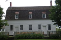
Like the Quakers, this Shaker church has no religious symbols. Men and women entered by separate doors and sat in their own half of the building. There wasn't a preacher either; members spoke when the spirit moved them.
|
|

|
In addition to farming for their own food, the Shakers sold excess food and other products. This man is demonstrating how the Shakers produced good quality brooms into the twentieth century. Unlike the Amish, the Shakers were quick to adopt new technology. They invented several things, including commercial-size clothes washing and drying equipment.
|
|

|
The Shakers apparently were industrious in their everyone-is-equal community. But they had one belief that certainly limited their growth. They didn't believe in marriage. They did not produce children of their own to become future members. And it seems that it was hard for them to convince adults to join their commune and become celibate. They apparently had far fewer men (brothers) than women (sisters). Late it their existence, when most of their members were women, they took in quite a few orphan children from Boston.
|
|

|
We went to a maple sugar farm in Vermont. This is the sugar barn, where the sap from sugar maple trees is boiled to become syrup and candy.
|
|

|
The Appalachian Trail, a walking path that goes along mountain ridges from northern Georgia to central Maine, crossed the road nearby.
|
|

|
Some of us walked about 100 yards up the trail. In this picture we are returning from the field above.
|
|

|
The footbridge across the stream.
|
|

|
A Texan on a Vermont footbridge.
|
|

|
Covered bridges were originally a practical solution to a bridge maintenance problem. There are plenty of trees in the hills of New England, so timber was a readily available building material. But in the wet climate, wooden bridges rotted fairly quickly and had to be rebuilt. So to keep the timbers dry they built a roof over the bridge. It was a good solution.
|
|

|
Now covered bridges are part of the quaint tourist appeal of New England. This bridge is in the Vermont picturesque village of Woodstock.
|
|

|
The next day we walked around Deerfield, Massachusetts, a few miles south of Vermont. This is the village inn.
|
|

|
The village church is very substantial.
|
|

|
This is the oldest house in the village. In its early years the village was on the frontier and was attacked by Indians.
|
|

|
The whole village has been very well preserved.
|
|

|
It's a pretty village.
|
|

|
We then drove west along a highway called the Mohawk Trail. The highway roughly follows an old Indian path.
We stopped in the curious small town of Shelburne Falls, where one of the attractions is the Flower Bridge.
|
|

|
It is a trolley bridge that was abandoned in the early twentieth century.
|
|

|
So the town turned the bridge into walkway and a flower garden.
|
|

|
It is a clever use for a derelict industrial facility.
|
|

|
Turning an eye-sore into a beauty spot
|
|

|
Another Shelburne Falls attraction is the round holes scoured into the rocks in the river during the glacier melt-off about 12,000 years ago.
|
|

|
Yet another attraction of the town for these visitors is the old fashioned ice cream counter in the drug store.
|
|

|
This is a view of the Berkshire Hills in western Massachusetts.
|
|

|
Here the bus driver is seen relaxing in an rocking chair.
|
|

|
We did not have much time for personal interests. The exception is that we got to see Rick, Amy, Annabelle (almost 2) and Caroline (2 months old).
|
|
|
|
Back to home page
|