Tinto
|
Back to home page
|
We have walked Tinto many times. The following pictures have been taken in a variety of seasons and weather conditions.
Below are some pictures with a narrative beside each one. Click on an image below to see a larger version of the picture. When viewing a larger picture, clicking "Next" allows you to look at the larger pictures one at a time.
|

|
Through out much of upper Lanarkshire, Tinto Hill (or simply Tinto, as most people refer to it) stands out prominently. It is a convenient place to get some exercise in the fresh air. When the weather is clear, the views in all directions are great.
|
|

|
There are four walking paths up Tinto, which can be simply referred to as the north path, the east path, the south path and the west path. Plotted in green are the four routes walked on different occasions, as recorded by a GPS receiver. If you zoom in on the first portion of the north route, you may be able to see that the GPS receiver recorded me walking in circles. There is an ancient hill fort beside the path and I walked on the top of all four concentric circular mounds.
|
|

|
The four routes walked are shown on this somewhat lower resolution map. The River Clyde flows near the base of Tinto on the north, east and south sides.
|
|

|
This map shows more clearly how the Clyde flows from the hills in the southwest, bends around Tinto and flows northwest to Glasgow. The light green plots of the four walking routes. Where we live is shown as a blue house on the south side of Glasgow. Driving to Tinto takes about 50 minutes. The town of Biggar is six miles east-northeast of Tinto. The town of Lanark is eight miles northwest of Tinto. Carnwath, where Rosemary grew up, is eight miles north-northeast of Tinto. As a child she could see Tinto from her school, until she went to high school in Lanark. This map also shows hills we have walked southeast of Coulter and Drumelzier.
|
|

|
Probably 90% of the people who walk up Tinto use the north path. The car park is at the center of this picture, beside the trees. One sees all kinds of people on the Tinto main path, including hill runners in shorts and running shoes, families in T-shirts not realizing that it is often substantially colder and windier on the top, and walkers wearing hiking boots and carrying enough clothing for a change in weather.
|
|

|
The pre-historic circular hill-fort is less than a half mile up the north path from where the car was left. In this picture the circular pattern can be seen to the right of the path. Archeologists have not dated the fort, but many such forts were occupied during the Iron Age, roughly 2500 years ago. The day that I walked around all four concentric circles it took me 25 minutes, but I didn't keep track of the distance walked during that 25 minutes.
|
|

|
Of the four circular defensive ramparts, the middle two are the highest, which are shown in this photo. There were probably log palisades along the top of each rampart to complete the defensive walls.
|
|

|
This picture was taken in the center of the fort, looking at the inner rampart and the path up Tinto beyond.
|
|

|
The heather was at it's purple best on this August day.
|
|

|
A bit higher on the hill this is the view looking back down the path.
|
|

|
This view is from a bit higher, taken in February when the heather was brown.
|
|

|
Higher on the hill on this February day I was sitting on some heather beside the path watching white puffs of cloud drift by.
|
|

|
On this April day there was a light dusting of snow on the upper portion of the hill. Much of the upper half of the main path is loose stones, as seen in this picture.
|
|

|
This view is a bit higher on the main path looking downward. It is an easy path to walk. The slope isn't steep, just steadily upward.
|
|

|
This view is looking up toward the top, which is in the cloud. One can barely see the cairn at the top, a large pile of stones.
|
|

|
This is what the huge pile of stones looks like on a sunny February day. There is a person standing on the top, beside the concrete marker that is about four feet high. Presumably the pile of stones was put there by people, but I don't know when or for what reason.
|
|

|
This view is looking down to the beginning of the east path. Beside the road at the center of the picture is the red car we had at that time. The path is through a gate into the green field, through a gate at the top of the green field and up the steeper slope in the foreground.
|
|

|
This picture was taken 20 minutes later on that foggy February day. When you have been on a path a number of times in the past, it doesn't matter that you can't see more than 100 feet ahead.
|
|

|
This is an August view, with heather in bloom beside the path and the Clyde Valley behind us. I had taken off my backpack for this picture. Rosemary had her sweatshirt tied around her waste because it was a warm windless day.
|
|

|
This is a February view from about the same spot., with the east path in the foreground and the Clyde Valley in the distance partially shrouded by cloud. I've walked that path the most because it isn't crowded with other people. It's good exercise going up 1500 feet of altitude. Sometimes I or we have gone up Tinto to rebuild fitness to walk up higher hills after several months of not being able to walk in the hills.
|
|

|
On several occasions I've wanted the exercise of walking up a Munro (a hill over 3000 feet in altitude) but there was too much risk of snow and ice, so I walked Tinto twice (up one path, down another path, back up that path and then back down the first path to the car). That gave me the climbing exercise of a Munro, but closer to home, a gentler path and less exposure to dangerous weather. Another advantage of Tinto is when I'm walking alone there is excellent mobile phone coverage on all of the paths, in case I were to twist an ankle and need help.
|
|

|
Near the top of the east path is evidence of past human activity. On the north side of the farm boundary fence the ground has been excavated. It doesn't look like quarrying, because the amount of soil excavated on the up-hill side seems to be about the same as the amount deposited on the down-hill side. However, the area isn't really leveled either. Then there is the steel mast that looks like it could have been for a radio aerial.
|
|

|
The most prominent relic are these two iron boxes well anchored into the hillside. They look like secure safes. They each had double locks on the old rusted doors. We haven't heard of the history of this site, so we are left with guessing. We think it may have been the site of a Second World War enemy aircraft observation post. Nazi bombers attacked the shipyards of Glasgow several times during the War, leaving heavy casualties in the crowded nearby tenements. We know of an antiaircraft gun position, in a field between Busby, Clarkston and Castlemilk. It seems very plausible that an observation station at Tinto would have been able to provide about 15 minutes notice of an approaching flight of enemy bombers, enough time to man the antiaircraft guns. But what was actually here remains a mystery. Was there a tent that covered these two safes, or a temporary building of which there is no longer any trace? If there was a tent or building, we wonder why the ground wouldn't be more level than it is today. What was contained in the safes? Were they for the storage of radio or telephone equipment when the observation site was not maned? Did they store encryption code books in the safe? If this was an aircraft early warning station, was the observation post actually on the top of Tinto (300 yards away) and this was the base camp? These are questions to ponder while walking up the hill.
|
|

|
This photo was taken from the top of Tinto looking northeast. The foreground shows the beginning of the descent down the eastern route, near the fence in the lower right corner. I normally ascend via the path which is not quite visible in this picture. Then I like to begin the descent on that smooth soft moss and heather surface seen in the foreground, and then join the path a little further down.
|
|

|
This picture was taken on the same February day as several of the earlier photos. By late afternoon the cloud had lifted enough that it was only covering the top of Tinto (in the left-center). The path up the upper slope angles up from the left side of this picture and then turns abruptly left. That left turn is where the two old iron safes are.
|
|

|
This view from the same spot shows the path downward. At this point the rate of descent is slight since this is near the top of the hill to the east of the main Tinto Hill. The map calls this hill Scaut Hill.
|
|

|
This is looking down at the path descending from Scaut Hill. The village down in the valley is Symington. The town of Biggar is normally visible beyond Symington, but the mist was too thick that day. There was a small gap in the overhead clouds that allowed the sun to shine briefly on some fields between Symington and Biggar.
|
|

|
This shows the grassy descent lower down the east path. The line of trees in the distance straight ahead are on the shoulder of a lower hill, called Wee Hill on the map, which is at the top of the final slope down to the car. Twice I have stayed too long on Tinto and ended up walking from about here back to the car in the dark. By walking slowly to reduce the risk of a twisted ankle I made it with no more damage than some cow manure on my hiking boot from the green field beside the road (which is normally full of cattle in the summer months).
|
|

|
This is a view of Tinto from about 15 miles away to the east. That noticeable notch on the left side of Tinto is called Wallace's Seat. I assume it has that name because William Wallace has a bigger than life image. He was essentially the leader of a band of guerrillas who opposed the English occupation of southern Scotland in the 1390s. Wallace certainly operated in this area -- his wife was taken hostage and then killed by the English occupying force only eight miles from Tinto. So it's possible he used it as a lookout site, but I don't think anyone knows that to be so.
|
|
|
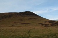
The south path up Tinto starts at Wiston Lodge, a facility operated by the YMCA as an outdoor recreation center. I park behind the main lodge and walk up the wooded track that goes gently uphill. One has to go through several livestock fields before reaching the open hillside seen in this picture. The last few times I've been up the south path, the facilities for crossing those fences were in need of repair.
|
|

|
This view is looking up at Wallace's Seat on a nice day in February. The path angles off to the right and climbs to the altitude of Wallace's Seat on a series of zigzags. The weather conditions were right for paragliders. In this picture there is one just to the right of Wallace's seat and another near the left edge of the picture.
|
|

|
As we ascended the heather-covered hill, the paragliders were closer.
|
|

|
When we were above Wallace's Seat we enjoyed watching this glider sailing by at the same altitude as we were. That's Scaut Hill beyond the glider.
|
|

|
This is the same glider 40 seconds later. He was perhaps 100 yards away from us.
|
|

|
About six minutes later, I think it was the same guy that sailed over us. We were nearly to the top of the hill at this point, so it looks like he sailed over the top of Tinto and is here riding the updraft from the southerly breeze that day.
|
|

|
This is a view looking down upon Wallace's Seat, on the right, on a chilly April day.
|
|

|
This is the view looking down from the brim of Wallace's Seat. Wiston Lodge is in the trees at the center of this picture. The south path descends on the zigzag route out of the view to the left, crosses through the heather from the lower left in this picture, and then along the field fences to the trees.
|
|

|
Near the bottom of Scaut Hill, at the lower edge of the brown heather seen in this picture, is a ruin of a medieval tower house. Not much remains -- just the foundation and a few pieces of wall. A tower house was a small castle built with thick stone walls. There was one room on each of three or four floors. The man who owned the agricultural valley seen in this picture down to the river probably built the tower house to protect his family. During the various wars 600, 700 and 800 years ago, bands of armed men no doubt went up and down the Clyde on their way to or from a battle. The local people needed a way to protect themselves, and particularly their wives and daughters, from the armed men passing through the valley. It is easy to envision people rushing to the tower house at the base of Scaut Hill for protection until a band of marauding men had passed by.
|
|

|
We have only walked the west path three times and haven't yet sought out a convenient place to park near Burnhead Cottage on the B7055, the Wiston to Rigside road. Our habit so far has been to drive up the track and park at a wide spot about a third of the way up. That seems to be the place where the paragliding people park. This picture was taken looking down at the gap between Lochlyloch Hill and wooded Howgate Hill. The steep-sided saddle between the two hills is called Howgate Mouth on the map. Some Roman road researchers have said this gap in the Tinto Hills was a Roman road and at least one Roman road searcher has said it was not Roman. I have not read those papers nor walked the area to see the evidence, but it seems plausible that it is a Roman route. The route has a constant gradient on each side of the gap and it would have been a direct route from the Roman sites to the south and the Roman fort north of here. After walking up the constant-gradient track, we walk up the steep but short hillside seen in the foreground of this picture. Then we follow the up and down of the ridge line, across Lochlyloch Hill and up Tinto.
|
|

|
Being the least used path up Tinto, it is entirely grassy. There have not been so many walkers that the grass has been worn away and the soil has eroded down to the loose stones beneath. There are a couple of boggy spots at the saddle between two higher portions of the route. The April day when this picture was taken was windy and chilly, but there was on and off sunshine.
|
|

|
This picture was taken near the west path. At the base of the northeast slope of Tinto, that is Lochlyoch Farm, where the Clydesdale horse is believed to have been first bred. The geographic name Clydesdale ("dale" means valley in southern Scotland and northern England, the area occupied by the Angles 1500 years ago) refers traditionally to the rich agricultural River Clyde Valley above the Falls of Clyde (near Lanark). The Clydesdale breed of horses is believed to have started with a Flemish (Belgian) stallion bred with Clyde Valley plow horse mares, by John Paterson at Lochlyoch in about the year 1720. A grandson or great-grandson, William Paterson married the sister of Rosemary's great-grandfather. There was a lot of intermarrying among the farming families of the upper Clyde Valley. The Clydesdale breed of horses were particularly large, strong and mild tempered. They were fine horses for pulling a plow through the heavy sodden peaty soil of the Clyde Valley. The industrial revolution, beginning in the late 1700s, brought a whole new market for the horses bred by the Clydesdale area farms. Large numbers of horses were needed for pulling wagons of coal, ore and other heavy loads to and from the foundries and factories of the Glasgow area. Later Clydesdale bred horses were exported to other places in the world as work horses.
|
|

|
While on the topic of Clydesdale horses, this picture of a gentle plow horse was taken in 1938. The farm is Westraw Mains. The River Clyde is about 500 feet away, on the other side of the field to the left of the photographer. The children are six years old, Rosemary's twin cousins Margaret and John. Since she grew up on that farm, it was probably Rosemary's mother, at age 18, who lifted little Margaret up onto the large horse.
|
|

|
On the windy chilly April day, we experienced a brief snow shower as we were descending back to the car. The grassy south slope of Lochlyoch Hill is fairly steep here. The car was parked beyond the clump of trees at the center of the picture.
|
|

|
On a mostly sunny day in August, this is a view from the top of Tinto looking toward the southeast. The River Clyde is clearly visible in the center of the valley below. Of the hills beyond the valley, the one to the right of center is Culter Fell.
|
|

|
This August picture was taken just below the top of Tinto, looking northwest. The misty line of hills on the horizon is the Scottish Highlands, about 75 miles away.
|
|

|
This April image of Tinto was taken on Culter Fell, seven miles southeast of Tinto. Scaut Hill is to the right of Tinto and Lochlyoch Hill is to the left of Tinto.
|
|

|
This view of Tinto, at the center of the photo, was taken 75 miles away along the Ptarmigan ridge of Ben Lomond. The city of Glasgow is in between.
|
|
|
|
Back to home page
|