|
|

|
It is a 180 mile drive along the Icefields Parkway from Banff to Jasper National Park, with picturesque mountains on both sides of the road. It is the most beautiful drive I know of. However, it was overcast all day. So we didn't stop very often for photos. |
|
|

|
This overlook above Peyto Lake is about a 15-minute walk from the Icefields Parkway. The blue of the water is amazing, especially since the sky was grey. |
|
|

|
When glaciers move they grind rocks together and turn them to dust. That produces a light grey silt on the bottom of lakes. Reflection from the light-colored bottom is part of the story. Some of the dust particles are smaller than grains of flour. Apparently there is a principle of physics called surface tension that causes the smaller grains of dust to remain suspended in the water rather than sink to the bottom. That apparently causes reflection to produce the bright blue of Peyto Lake. |
|
|

|
We have seen the reflection of bright colors from all of the Rocky Mountain lakes, in differing degrees. This lake is more green than blue. I don't know whether the grains of dust ground from different mountains have different reflection properties. There is a lot about glaciers that I don't understand, but this visit to the Canadian Rockies has been informative. |
|
|

|
This is Athabasca Glacier, the largest glacier we have seen. It is too bad the weather was so colorless, it makes the photo look like a black and white picture. |
|
|

|
While we were driving northward to Jasper, the grey weather was a fierce storm behind us. The main Trans-Canada Highway was washed away five or ten miles east of Banff, Calgary had serious floods, etc. We had some rain during the night, but all of the devastation occurred where we had been. |
|
|

|
This bear was grazing beside a road close to the town of Jasper. |
|
|

|
Soon her two cubs appeared. Our guess is that they were yearling cubs, since they were noticeably larger than the three cubs we saw in Waterton National Park a few weeks earlier. |
|
|

|
Soon she led her cubs into the woods. |
|
|

|
We walked along the several paths of the Valley of the Five Lakes Trail. |
|
|

|
Except for the grey sky it was a very pleasant walk of 6.3 miles that included about 500 feet of climbing. |
|
|

|
At this northern latitude (53º) spring wildflowers are in bloom in mid-June. |
|
|

|
I enjoy the sharp red/orange of Indian Paintbrush. |
|
|

|
°The water is clean and clear. The glacial silt is clearly visible on the bottom. I don't know why the grey silt is visible as green. |
|
|

|
The green ponds look nice. |
|
|

|
I don't know why Peyto Lake was so blue and this lake so green. |
|
|

|
The return path is along a ridge. |
|
|

|
One of the through-the-mountains tourist trains parked for the night in downtown Jasper. Seeing the Canadian Rockies from a car and walking is far better than riding in a train, as far as I'm concerned. |
|
|

|
There are several horses in fenced area beside their barn. When I first saw them the unfenced elk and one of the fenced horses seemed to be communicating face to face. I wondered if the elk was teasing with something like, "You have to be fenced in and have to eat dry hay, while I'm free to go anywhere and eat all of this green stuff." |
|
|

|
There were lots of elk contentedly in human areas. I wonder if this one is pregnant. |
|
|
|
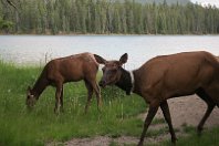
This pair wasn't concerned that I was snapping pictures from less than 20 feet away. |
|
|

|
This male elk was grazing leaves off of bushes beside the road. |
|
|
|
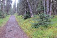
We parked at Beaver Creek on the Maligne Road and walked up and back the Jacques Lake Trail for a total distance of 13 miles. |
|
|

|
Beaver Lake was very tranquil on this overcast day. |
|
|

|
A pleasant walking path to the second lake. |
|
|

|
Up to our left the snow-melt in the steep gullies is almost finished for the year. |
|
|
|
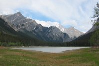
The first of the two Summit Lakes. I don't understand how it works, but this lake did not have an outlet stream. Water did not flow out of this lake, that we could see. Possibly it is only a lake during the spring snow melt. |
|
|

|
The second Summit Lake also did not appear to have a creek flowing out of it. |
|
|

|
However, it was a good spot to eat our lunch sandwiches. |
|
|

|
Finally there is some sunshine. |
|
|

|
It had rained during the night 30 hours before we walked there. After we saw this bear track in the mud we paid more attention to the advise of Park Rangers -- to talk loudly so any bears in the area will know humans are approaching. It feels silly in the woods to talk loud or attempt to sing. That preventative seemed to work -- we did not see the bear that left this foot print. |
|
|

|
Two days later, Ann and Ian walked this same path. Ian was preparing to photograph a wild orchard. Ann looked around and saw a black bear coming up the trail. |
|
|

|
She touched Ian's shoulder and in a shaky voice said, "Bear!" Ian swung around, and being a veteran wildlife photographer, he snapped a photo fo the bear while at the same time retreating off of the trail and speaking to the bear in a calm but fairly loud voice. The bear never looked at the two people, it just kept on walking until it was out of sight. |
|
|

|
This is Ian's picture of the bear walking toward them. |
|
|

|
The Athabasca River flowed past the place where we stayed, a couple of miles south of the town of Jasper. Rather than flowing east to Hudson Bay, as in Banff National Park, this river flows north, to the Arctic Ocean, via the MacKenzie River. |
|
|

|
We saw this big elk buck along the road. |
|
|

|
This is the Maligne River. It appears to be carrying quite a bit of grey glacial silt. In the sunshine there is a hint of green too. |
|
|
|
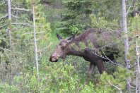
We had expected to see quite a few moose, but this is the only one we saw. We think it might be a young male, with small horns. |
|
|

|
The only way to see the scenery of Maligne Lake is to go on the tour boat. |
|
|

|
The view along the shore of Maligne Lake. |
|
|

|
Unfortunately, the grey sky has taken almost all of the color from the scenes. |
|
|

|
Spirit Island in Lake Maligne is one of the most iconic images in the Canadian Rockies. |
|
|

|
However, with the grey sky the scenes lack color. |
|
|

|
Relaxing with cousins on the lawn at Jasper Park Lodge (which is not where we stayed). |
|
|

|
Majestic mountain scenery in the Canadian Rockies -- I have wanted to see this area for about 50 years, and finally got there in 2013. The thing that surprised me is that it isn't just a few majestic scenes -- there are hundreds of them stretching along hundreds of miles. |
|
|

|
Mount Edith Cavell |
|
|

|
A tongue of glacial ice extending over the brim from the Angel Glacier, on the north slope of Mount Edith Cavell. The whole valley where we were when this photo was snapped was once a glacier. I don't know how long ago that was. |
|
|

|
This view is looking northward, back down the valley toward Cavell Lake. |
|
|

|
This is looking southeastward toward the slopes of Mount Edith Cavell. |
|
|

|
The bulk of Angel Glacier is up in that relatively flat hollow below the upper slope of Mount Edith Cavell. |
|
|

|
Below the moraine of gravel and boulders (left by the glacier that retreated decades ago) we were on, is Cavell Pond which is full of floating ice in this picture. |
|
|

|
I believe the stripes of brown on the glacial ice on the far side of the pond mark the years. |
|
|

|
A few weeks earlier, in the middle of the night when no one was there, so much ice and snow fell off of the mountain that it splashed all of the water out of the pond. The resultant tsunami of water washed away all vegetation and about 50 feet of the road. When we were there, the missing road had been filled with (readily available) moraine gravel, but it had not yet been repaved. |
|
|

|
The park rangers did not prohibit us from walking down to the edge of the pond, but they urged us to not spend long there since no one could tell if there would be another avalanche that would put us at risk. |
|
|

|
Aqua blue water and melting chunk of ice. |
|
|

|
The tsunomi left huge chunks of ice sitting on the gravel near the pond. |
|
|

|
The melting crack in the huge piece of ice shows the blue tint of ice that has been under very high pressure, due to the massive amount of ice weighing it down from above. This summer I learned more than I had every previously learned about glacial ice. |
|
|

|
Athabasca Falls. There is a lot of water going over the falls. |
|
|

|
Another view of Athabasca Falls. |
|
|

|
Young male elk grazing beside the road. |
|
|

|
And, walking leisurely across the highway. The main Trans-Canada Highway, through Banff National Park, had been washed out four or five days earlier. This was the only highway through the Rockies that remained open for traffic. So this meandering elk was holding up cross-country truckers. |
|
|

|
Moonlight Serenity could be the name of this picture. This is the Athabasca River in front of the place where we stayed. Jane snapped this picture -- I didn't think of going out after dark. |
|
|
|
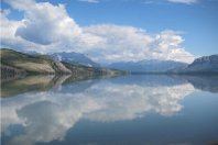
Reflections in Jasper Lake |
|
|

|
A shaggy white mountain goat. |
|
|

|
The young mountain goat was cute. |
|
|

|
A big horn sheep on the same hillside close to the Yellowhead Highway (the sole east-west highway with the bridge washed out near Banff). |
|
|

|
We parked at the Miette Hot Springs spa and resort and hiked up the Sulphur Skyline Trail. That's Sulphur Ridge, our destination, off to our right during the first phase of our hike. |
|
|

|
This is the view looking up to our left as we walked. |
|
|

|
There were some Indian Paintbrush wild flowers along the trail. |
|
|

|
It was an excellent path up through the trees. |
|
|

|
As we got above the tree line, the views were of endless mountains. |
|
|

|
This view shows the hot springs resort down in the valley. |
|
|

|
It seems more appropriate to see a mountain goat, in this case a brown one, high on a mountain, rather than down near the highway. |
|
|

|
Ashlar Ridge presents an impressive sheer rock face. |
|
|

|
This is the only mountain we experienced in the Canadian Rockies where we could walk to the top. According to the GPS receiver we walked 7.9 miles while climbing 2370 feet. |
|
|

|
While descending I noticed the distinctive U-shape of the valley. I believe that indicates that an ice-age glacier cut out the valley leaving the ridges on each side. |
|
|

|
While driving down the Miette Hot Springs Road back to the highway, we came upon this black bear grazing in the weeds and bushes beside the road. This photo was snapped out the window of the car (the door mirror is visible in the lower right corner). The bear was not concerned with the car that was several feet away. |
|
|

|
The bear then crossed the road in front of the car. |
|
|

|
He grazed beside the road while we snapped photos out of the open window. |
|
|

|
At this point he has stopped eating and is walking down the road while the car is moving at his pace just ten or 12 feet away. |
|
|
|
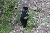
He then turned and walked up the embankment. Though he did not pay any attention to us, we wonder if our presence was disturbing his evening meal. I'm saying "he" out of ignorance of the bear's gender. We didn't see any cubs so our guess is that this bear is male, perhaps a fairly young male. |
|
|

|
While in Jasper National Park we stayed in this cute 1950s style cabin. |
|
|

|
It was a bit cramped in places but we managed just fine. |
|
|

|
Until I got the Canadian Rockies the only elk I had ever seen were a half -mile away. Here they are everywhere. |
|
|

|
Colorful Indian Paintbrush beside the highway. |
|
|

|
Mount Robson is the highest mountain in Canada. When we stopped to take a photograph the top was shrouded in clouds. |
|
|

|
From the same parking place beside the highway, this is the view looking the other way, southward across the highway. I don't know the name of that mountain, but not being cloud-covered it is more photogenic. |