|
|

|
Waterton National Park, in Alberta, Canada, is across the border from the US Glacier National Park. This picture, looking south from the Bear's Hump outcrop, shows the village of Waterton and Upper Waterton Lake. The south end of the lake and the distant mountains are across the border in Glacier National Park. |
|
|

|
Wildflowers (Indian Paintbrush) along the Bear's Hump Trail. |
|
|

|
The herd of bighorn sheep, seen here to be losing their winter wool, were using the road to wander into town to graze. |
|
|

|
A waterfall and canyon along Cameron Creek. |
|
|

|
It was mostly cloudy over Cameron so the water looked grey. However, there was a lot of snow still on the mountain at the south end of the lake, which is actually in US Glacier National Park. |
|
|

|
We walked along the west side of the lake. There were several pieces of ice still floating on the lake from the winter. |
|
|

|
The mountain in the distance is apparently Chapman Peak, four or five miles away. |
|
|

|
It isn't clear which is snow that will melt during the summer and which is glacier ice. |
|
|

|
The path back along Cameron Lake toward the car. Walking from our motel up to Bear's Hump, plus walking along Cameron Lake, plus walking to Akamina Lake totaled 7.2 miles that day and we climbed about 800 feet. |
|
|

|
While driving back toward Waterton Village from Cameron Lake, we stopped to watch two bears, apparently grazing on dandelions beside the road. |
|
|

|
A few other cars came and went but they were our first bears so we watched for a while. This picture was snapped while standing outside of the car, ready to jump back into the car if the bears came closer. |
|
|

|
We then drove slowly up to the bears and took more photos out of the window of the car. |
|
|

|
We were only 12 - 15 feet away but they weren't interested in us. A Canadian hunter told us later that this was a black bear with light brown coloring. |
|
|

|
Heading up the Blakiston Creek Valley on the Red Rock Parkway, the roadside wildflowers with Mount Blakiston in the distance. While driving up Red Rock Parkway we saw a grey wolf cross the road ahead of us but it was gone before we could get a camera ready. |
|
|

|
An example of the red rocks, the basis for the name of the road, with Mount Blakiston ahead. |
|
|

|
Ruby Ridge from about two miles away. |
|
|

|
Mount Blakiston from about three miles to the east. |
|
|

|
Anderson Peak from a creek-side meadow about three miles away. |
|
|

|
Mount Blakiston from the meadow about two miles to the northeast. |
|
|

|
Red Rock Creek. |
|
|

|
We walked westward along the Snowshoe Trail, up the valley of Bauerman Creek. About seven miles west of here this track crosses the Continental Divide. Native Indians used this track to cross the mountains. |
|
|

|
This is a view of Anderson Peak from the Snowshoe Trail. |
|
|

|
After roughly three miles up the Snowshoe Trail we headed uphill on the Goat Lake Trail. |
|
|

|
Across the valley we got lots of glimpses of Anderson Peak, about a mile and a half away. |
|
|

|
It became warm climbing the hill in the sunshine. |
|
|

|
I like the color of Indian Paintbrush and the mountain in the distance. |
|
|

|
The path continued up the side of the hill. |
|
|
|
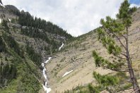
The goal, Goat Lake, is up above that notch, but we didn't make it all the way. |
|
|

|
We stopped for lunch at a wide spot on the stoney path. |
|
|

|
We decided we had had enough of the stoney slope. After lunch we went back down the path seen here, crossing several patches of melting snow. |
|
|

|
It was nice being back down onto a solid path, without loose stones. |
|
|

|
It was a delightful path. |
|
|

|
Back down on the Snowshoe Trail, this is one of two stream crossings. We crossed the fast moving water on a few logs and stepping stones. |
|
|

|
The path down the valley was very pleasant. |
|
|

|
We saw a deer ahead and stopped. With camera in hand I slowly inched forward. |
|
|

|
When I was less than 20 feet from her, she looked up from grazing. The deer was looking past me at Rosemary's pink shirt. |
|
|

|
She slowly ambled off of the path into the woods. We think she was a mule deer. |
|
|

|
The Blakiston Falls Overlook. |
|
|

|
Blakiston Falls. |
|
|

|
Blakiston Creek rushing toward the Falls. |
|
|
|
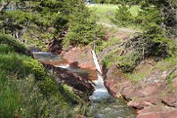
This is a view of Red Rock Creek. Our car is one of the few remaining in the parking lot -- it is barely visible at the top edge of this photo, in the center. Our hike went a distance of 10.5 miles and climbed about 1320 feet. |
|
|

|
This is surely the classic shape of a beaver lodge, but we didn't see any beavers in this pond. |
|
|

|
In early evening, while driving east on Red Rock Parkway, down the valley of Blakiston Creek, we saw a bear with her small cubs near the road. We stopped and backed up to get pictures out the passenger window. |
|
|

|
She was fully occupied grazing in the brush, even though our car was only ten feet away with the engine running. While we watched, one of the cubs went around her and started toward us. With her mouth she picked up the cub by the scruff of his neck and threw him to the other side. Clearly she was teaching the cub to ignore the car and the people. |
|
|

|
A few minutes later she started wandering away from the road with her cubs. |
|
|

|
There were three cubs, all the same size, two of them black and the third was brown. |
|
|

|
Here the brown cub seems to be saying, "But Mama, I want to go back and see the people." However, he didn't act on that impulse. He turned and followed his mother into the brush. |