Ben Ime from Glen Kinglas
|
Back to home page
|
I've been exploring the hills between Arrochar and Loch Fyne. These are the back sides of the "Arrochar Alps," an informal term that I believe refers primarily to Ben Arthur (The Cobbler), Ben Narnain and Ben Ime behind Ben Narnain, which are normally accessed from the car park just west of Arrochar on the shore of Loch Long. Walking up Ben Narnain is a full Munro (climbing 3000 feet) since it starts only a few feet above the Loch Long high tide mark. The hills to the west are not nearly as popular, I suppose because they are not Munros and they are a bit further away from Glasgow. These photos were taken on 12 June 2010.
Below are some pictures with a narrative beside each one. Click on an image below to see a larger version of the picture. When viewing a larger picture, clicking "Next" allows you to look at the larger pictures one at a time.
|
|
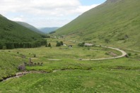
At the center of this picture is a stone bridge built about 260 years ago, after the Highland uprising in 1745. It was part of a land route from Glasgow to the Argyll peninsula for the British army. Just to right of the old bridge is a large parking area beside the modern road, which is where I parked. I walked across the modern highway and went perhaps a hundred yards up the track visible at the right edge of this picture. Then I crossed the river, the Kinglas Water, which was about 20 feet wide, by walking on flat dry stones. I learned two months later that the water in that river isn't always as low -- it August the river couldn't be crossed and neither could the burn seen in the foreground. On the left of this picture, just across the burn, there are some remaining stone walls of a Highland home.
|
|
|
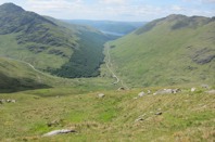
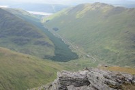
Further up the trackless grassy slope of Ben Chorranach, this is the view down into the valley of the Kinglas Water. Loch Fyne, the sea loch that forms the eastern shore of the Argyll Peninsula, is beginning to be visible at the mouth of Glen Kinglas.
|
|
|
Higher on Ben Chorranach there are more rock outcrops but there are still plenty of grassy routes between the rocks. When adequately fit, it is a delightful hill to walk up -- soft grass and moss to walk on, a variety of scenery in various directions, very few other people and it's safe since there is fine cell phone coverage due to the major road in the valley below. However, it is difficult to get to this dry grassy slope when there is a lot of water flowing in the Kinglas Water and the seemingly unnamed burn that drains the corrie (valley) between Bens Chorranach, Ime and Luibhean.
|
|

|
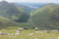
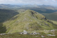
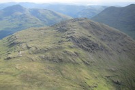
From the top of Ben Chorranach, this is the view of the next hill to the south, Ben Ime. I have previously been up the other side of Ben Ime, but never this side. About two-thirds of the way up Ben Ime from this distance it looks like a difficult section of rocks, but when I got there I discovered a zigzag path that made the ascent easy.
|
|

|
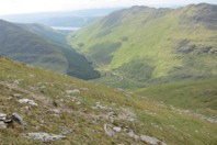
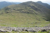
This view is looking back at Ben Chorranach from beyond the saddle between Ben Ime and Ben Chorranach. As can be seen in this photo, while descending that side of Ben Chorranach, I had to pick grassy routes around the rock outcrops. And while crossing the saddle I sought a route that avoided the sodden bogs.
|
|
|
From the north slope of Ben Ime, this view is looking west down Glen Kinglas. Note that the angle of the slope that looked rather steep from the other hill is actually less than 30°. A portion of the zigzag path is visible on the left foreground of this picture.
|
|
|
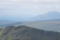
From near the top of Ben Ime, this is the view looking back toward Ben Chorranach. The Hills further into the Highlands are on the horizon. Ben Lui is the higher one. It is 11 miles to the north. We haven't had a chance to go up Ben Lui yet.
|
|
|
In the distance, just to the left of the center of this photo, about 18 miles to the northwest, is Ben Cruachan. A few days earlier some rocks fell off of the hill and damaged the railway track. The train to Oban was derailed and nearly fell onto the highway far below. The train crew got all of the people off hurriedly, fearing that the precariously balanced railway car was about to fall down the mountain. No one was hurt, but the road to Oban was closed for a week while they brought in and assembled a large enough crane to lift the railway cars, and then they repaired the damaged railway track. |
|
|
This is the view from the highest point on Ben Ime looking to the north. In the foreground are the rocks and grass on the top of the hill.
|
|
|
This is the view from the same spot looking westward.
|
|
|
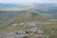
From the same spot at the top of Ben Ime, this is the view to the southwest, of Ben Luibhean. That was where I walked next. From a distance it looks like it would be difficult to get to the top of Ben Luibhean, but there were easy routes. Some had been used by enough people that there was an evident path.
|
|
|
This is a view of the saddle between Ben Ime and Ben Luibhean, from the lower south slope of Ben Ime. The better route down this slope was to avoid the exposed rocks seen in the foreground of this photo, by veering off to the left.
|
|

|
From the saddle between Ben Ime and Ben Luibhean, this photo looks eastward back at Ben Ime. I had descended southward along the ridge, and then descended westward down the slope on the right portion of this picture.
|
|
|
From the same spot in the saddle this is the view of the east slope of Ben Luibhean, that I ascended next.
|
|

|
Part way up the east slope of Ben Luibhean there was this cluster of wildflowers. They were small and low to the ground, but colorful. I don't know the name of the flowers.
|
|
|
From the top of Ben Luibhean, this is the view to the northwest. I was ready to return to the car parked just past the bend on the modern road down in Glen Kinglas.
|
|

|
Most of the descending route down the ridge line went quickly on grass. But the lower portion of the hill had been a timber forest that had been cut some years back leaving many stumps and branches -- it was slow walking through them. The next time I walked in the area, two months later, I tried a different route through that mess and it wasn't any better.
|
|
|
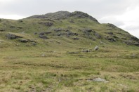
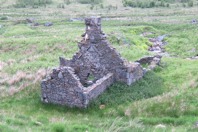
This is the stone ruin of a Highland home that is an unknown number of centuries old. The burn (stream) is just beyond the house on the right side of this picture. The house and the setting reminded me of the folk song lyrics that refers to Granny's Heilan Hame.
|
|
|
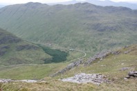
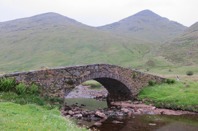
This is the bridge built in the 1750s. The hill on the left is Ben Chorranach. Ben Ime is on the right. Only the lower slope of Ben Luibhean is visible on the right edge of this photo. The walk that day up those three hills was about six miles in lengh and climbed a total of about 3800 feet.
|
|
|
|
Back to home page
|