Newly discovered possible Roman road in central Lanarkshire
Back to Roman road page
The route has been documented as a summary report printed in the summer of 2008 in the journal: Discovery and Excavation in Scotland, New Series Volume 8, 2007. A detailed report has also been submitted in the spring of 2008 to the Royal Commission on the Ancient and Historical Monuments of Scotland (RCAHMS).
The intention of these pictures is more for family and friends. Therefore the language is not targeted for Scottish archeologists. Also, the narrative and spelling in the captions of these pictures has an American accent.
Two-dimensional photographs are not able to convey as much as observing while walking across the terrain. A camera lens simply can not capture a three-dimensional impression of the land, nor can it convey rising and falling slopes. But even with these limitations, possibly the pictures add to the written descriptions and maps included in the reports.
Below are some pictures with a narrative beside each one. Click on an image below to see a larger version of the picture. When viewing a larger picture, clicking "Next" allows you to look at the larger pictures one at a time.

|
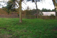
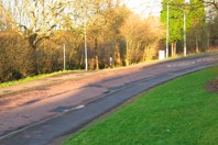
A few miles south of Stonehouse, west of Dykehead Road, this view is looking west-southwest toward Loudoun Hill (which is not visible here). In the mid-1700s William Roy first documented this as the route of the Roman road built in AD 82 or very soon thereafter. That military road connected the Roman fort at the base of Loudoun Hill with the Roman fort on the bank of the River Clyde near present-day Carstairs (a few miles east of Lanark). There are ruts in the grass here from a heavy tractor driving on sodden soil. In the foreground of this photo is a rock exposed on the surface. It could be a Roman bottoming stone that has been brought to the surface by modern farm machinery or left on the surface by amateur archeologists. |

|
This view is looking east-northeast along the line of the long-known Roman road. The water seen in the foreground is a tractor wheel rut. The heavy tractor seems to have squished out all of the soil above the Roman bottoming stones. The bottom of the tractor rut is stone. This site was used to test the idea that bottoming stones could be detected by pushing a thin steel rod into the soil. A method was developed for identifying a layer of stones beneath the soil. Probing across the route of this Roman road, solid stone was found at nearly 100% of the probed positions, while the natural stone density beyond the edge of the road was less than 30%. Note that the tree line on the distant horizon of this picture is the same as on the next picture taken a couple of hundred yards east-northeast along the route of the long-known Roman road. The blue barrel seen in this picture is a grain feeding device, perhaps for pheasants. |

|
Just east of Dykehead Road, the long-known Roman route is to the right of the field boundary hedge on the left, down the present farm track in the foreground and continuing up the next slope along the field boundary trees. The current surface of the tractor track certainly isn't Roman since it includes broken bricks and concrete, clearly from a demolished building. There is a photo taken at this same spot in Professor Keppie's book "Scotland's Roman Remains" on page 40. A couple hundred yards beyond the top of the slope seen the distant center of this picture is where the newly discovered possible Roman route branches away from this route. When I first lived in Scotland in the mid-1990s I cycled on Dykehead Road about a hundred yards behind where this picture was snapped. The map mentioned that this was the route of a Roman road. I wanted to explore it, but at that time I didn't know that in Scotland one is free to roam on private farmland as long as one doesn't harm anything. In January 2005 I began exploring this Roman road. I explored quite a bit before I stumbled upon evidence that there might have been one or more roads branching off of the long-known Roman road. |

|
This photo was taken five to ten yards to the left of the previous photo, from the other side of the field boundary hedge. On the horizon in the center of this picture, the town of Carluke can be seen. Carluke is nine miles away on the other side of the valley of the River Clyde. Along the ridge immediately beyond Carluke was the route of the Roman military road from their fort near Carstairs to a Roman fort near Motherwell. A junction with that road seems to be the destination of the Roman road explored. |

|
The fence along the left of this picture is a continuation of the straight field boundary hedge back near Dykehead Road. This point is about a half mile east-northeast of Dykehead Road. The view is looking along the route first identified by General Roy 250 years ago. At this spot it certainly doesn't look like a Roman road. About 100 feet in front of where this photo was snapped, the connection route seems to begin. |

|
Overlaid on a modern map of West Central Scotland, Roman and possible Roman roads are plotted. The Roman route plotted in red along the top of the map is the Antonine Wall, a defensive line that the Romans build to separate them from the natives further north. Along the bottom of the map, plotted in red and green, is the Roman route between the Loudoun Hill fort and the Castledykes fort near Carstairs. From the lower right corner to the center of this map, plotted mostly in red, is the Roman road from their Castledykes fort near Carstairs to their Bothwellhaugh fort near Motherwell. That road no doubt continued to the Antonine Wall but it is plotted in green because seemingly no trace of it has been identified due to the development of Glasgow in recent centuries. Plotted in blue is the eight-mile connection route that has been studied in considerable detail. The remaining pictures in this photo album were taken along that route. The route has been documented for Scottish archeologists. During the field walking while researching the connection route plotted in blue, two other possible routes were noticed. They are plotted on this map in grey. They have not been studied as thoroughly. At the northeast end of the connection route studied thoroughly, it looks like the long-known Roman road might have gone straight west into present-day Carluke and then turned northwest toward Wishaw and Motherwell, rather than cross Belstane Burn and the boggy land of Garrion Burn as has been speculated by past Roman road searchers. That speculated route is plotted in green while the possibility hereby offered is plotted in grey. The other possible route that has not been explored thoroughly is near the southwest end of the connection route. It looks like there might have been a shorter route from Loudoun Hill to Carstairs. There is a plausible crossing of the Cander Water south of Tanhill and Gill Farms. It could have crossed the River Nethan east of present-day Kirkmuirhill. That route could then have gone past Auchenheath and over the south shoulder of Black Hill along the rural lane still in use. Possibly when the Romans returned to Scotland after withdrawing to England for a half century, they could have built new Cander crossings, one heading east toward Lanark and Carstairs and the other heading northeast toward Carluke. The detail report includes three additional maps showing much more detail of the newly suggested connection route, each map covering about three miles. |

|
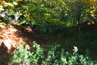
This is not an auspicious beginning of the eight-mile connection route recently found. It certainly doesn't look like a road junction today. But following the higher ground on the right of this picture, to the north-northeast, within a few hundred yards there is plausible evidence of an ancient road. The standing water in the foreground of this picture is because it is a boggy saddle between two small hills. Drainage is via the stream seen along the left edge of this photo. That stream becomes a ravine within a hundred yards. |

|
This photo is taken off to the left of the route. The route crosses from right to left on the relatively flat field ahead. It seems that the route could have been chosen to avoid the ravine shown in the foreground. |

|
After the route emerges from the wooded area, it follows a very gentle down slope straight ahead in the center of this picture. The altitude of this area is indicated by the fact that one can see in the distance, on the left side of this picture, the urban areas of Wishaw on the other side of the Clyde about eight miles from here. |

|
At the far side of this gently sloping field is a small stream. At the center of this picture, one can just begin to see an indentation in the surface of the field. The ruin of Castlehill farmstead is seen on the left edge of this picture. Since the first plausible evidence of the connection route was found just below the farmstead, Castlehill became part of the name of the route, as used in the reports to Scottish archaeologists. |

|
As the slope becomes steeper close to the stream the indentation in the surface of the field becomes clear. This is the only spot where the slope down to the small stream is on a constant gradient. The center of this picture looks like a man-made slope, in comparison to the rest of the hillside. |

|
From the upper end of the apparent cut, the steady slope down to the small stream is more apparent. Standing in the field, this constant-gradient down-slope can be better discerned than through a camera lens. |

|
At the bottom of the slope, the stream shifts sharply from one side of the fence to the other. It looks like there could have been a culvert to allow the stream to pass under the road. The width of the stream is in most places less than two feet. |

|
This photo was taken at the fence looking at the gentle up-slope of the next field. Probing about 15 yards ahead showed apparent bottoming stones across the width of the route. The route seems to continue straight ahead up the slope in the center of this picture. The fact that these three pieces of evidence (a possible hillside cut to maintain a constant gradient descent, a kink in the flow path of the stream and probe-detected apparent bottoming stones) are in close proximity, adds credibility to the evidence. The late afternoon shadows show that when this photo was snapped I was standing beside the fence post that can be seen in the previous photo about a yard to the left of my shadow in that picture. My shadow looks fat because I was wearing a backpack and two layers of jacket on that chilly November day, though it looks like my jacket is hanging open, unzipped. The day I probed the soil at this spot for bottoming stones, work that takes several hours, I experienced the acceptance of farmers for someone in their field. The farmer was plowing the field over the hill to the north. I didn't know whether he had seen me or not. When he finished plowing he drove down to where I was and shut off his big diesel engine. I explained what I was doing. In his unemotional man-of-few-words way, that I gather is typical of Lanarkshire farmers, we chatted for 15 minutes. There were silent gaps in the conversation when neither of us could think of anything to say, but he didn't start his tractor and drive away. And what was most remarkable for me is that he said nothing that left me feeling anything but welcome in his field. |

|
Several hundred yards further to the north-northeast, the route seems to turn in the flat featureless field just behind where this picture was taken. The route seems to then go east-northeast, along the north side of a field boundary that goes straight for over a half mile, on a map bearing of 61°, which is straight ahead in the center of this picture. There is another interesting thing about this picture. About 20 feet in front of the photographer there is a cross fence. There is now a gap in that fence, as seen in this picture, to allow modern farm equipment to go between the two fields. At both the left and right edge of this picture there is a pile of stones. There are no stones seen anywhere else along that fence. One wonders if Roman bottoming stones were in recent decades dug out of the low spots along the cross fence line and put aside out of the way. |

|
From this point, the route seems to be just to the left of the field boundary hedge seen on the right, which continues down to the stream and up to the top of the next hill. The ground was probed for bottoming stones just beyond the brim of the down-slope seen at the center of this picture. The probing showed apparent bottoming stones. |

|
The small river, about ten feet wide, that flows from right to left in the trees at the bottom of this slope, is called the Cander Water. The slope down to the river at the center of this picture is of a surprisingly constant gradient, in sharp contrast to the steep fall on the right of this picture. |

|
Down closer to the Cander Water, the ground was probed and apparent bottoming stones were found across the width of the route. The ground becomes flat 30 to 40 feet before the edge of the river. There is evidence that the Cander once flowed in that flat sandy bottom, on this side of the large trees seen in this picture. It looks like the river may have been diverted, perhaps during the 1800s, to channel the water to a mill or other water powered device. An old map says there was a sluice here. And there was a coal mine in the currently wooded area on the other side of the Cander Water. |

|
This view is of the flat ground immediately before the Cander Water. It is possible that there was a bridge across the former flow of the Cander. If so, there might be evidence of a bridge beneath this ground. It would be an interesting site for electronic subsoil scanning. Having found this plausible crossing of the Cander, one wonders about the motive for building it less than a mile downstream of the original crossing (the one on the straight route identified in the 1700s and further documented in the mid-1900s near Gill Farm). The Roman army seemingly occupied Scotland for less than ten years following their invasion in AD 82. About 50 years later the army reoccupied the abandoned forts. It is reasonable that they then performed maintenance on the road network. After a half century, the Cander crossing could have easily been destroyed by floods. I have seen fences washed out by the shifting sand banks of the Cander. At the potential Cander crossing shown here, the valley has narrowed so that there is solid ground on each side, but before the river falls into a steep-sided ravine, starting about 100 yards to the left. This would seem to be a more stable and permanent crossing site than the one the Romans hastily selected immediately following the initial invasion. |

|
On the east bank of the Cander, a constant-gradient up-slope continues to the left of the straight field boundary. To the right, beyond the fence, the ground is lower than here, and to the left is a hill covered with mining waste. Near the top of this wooded slope in the center of this picture is the abandoned mine shaft. |

|
From the upper edge of the mining operation the slope continues up the hill where the cows are in this picture. It seems that the route that may have been Roman was used as recently as the mid-1900s as a mine access road up to the highway near the top of the hill. Grass has mostly covered the mining waste gravel that surfaced that road. |

|
Near the top of the hill the terrain is flattening. The field boundary hedge on the right is in the straight line that has been followed for a half mile. The hedge/fence straight ahead is along the Larkhall to Lesmahagow highway, originally built in the early 1800s as the Glasgow to Carlisle toll road. Across that highway there is a narrow strip of land and then the motorway built in the 1970s. The narrow field is no more than 50 yards wide. The tallest trees seen in the distance and the mobile phone tower on the right edge of the picture are in that narrow field. |
|
Because of the prickly gorse brush, a picture of the narrow field from fence to fence is not possible at this spot. This picture shows about three-quarters of the width of the 50-yard-wide field. The field-boundary hedge line that has been followed for over a half mile, on an east-northeast map bearing of 61°, is seen as a straight hump that ends at the fence where a tree is seen growing from the hump. The fuzzy silver and red image beyond the fence is a trailer truck on the motorway going north at 70 mph. The 50-yard-wide field appears surprisingly undisturbed by the construction of the two major highways. So the soil was probed across the route at two locations, first a few feet this side of the tree seen in the left center and a second time in the foreground of this picture. In each case a clear pattern of bottoming stones was identified with few stones beyond the edges of the route. |

|
This view is looking south-southeast from about 150 feet away from the previous picture. In the foreground is a mound surrounded by a defensive ditch. Most of the square or rectangular mound was destroyed by the construction of the motorway on the other side of the fence. As far as has been determined, no archaeological work has been done on the mound and surrounding defences that might determine when it was built. It is probably between 1000 to 3000 years old. Since it is on a hill top and a Roman road seems to cross the hill just 150 feet away, the mound might have been the site of a Roman watch tower. It was common for the Roman army to station troops at watch stations along important roads. This site has clear visibility back to the high ground at Dykehead road, another promising site for a Roman watch tower. |

|
Changes in the direction of Roman roads often occurred at hilltops where it was easy to layout a straight road to the next natural obstacle. The hilltop beside the motorway seemed a reasonable place for a change in direction, perhaps more northward, toward Dalserf for example. After considerable looking, a plausible route in that direction was not found. So possibly the route continued straight along the 61° map bearing that had been followed from before the Cander crossing. About a half mile eastward along that line there is segment of man-made drainage ditch that for a couple hundred yards is straight and perfectly aligned with the 61° bearing line previously followed. It was clearly dug to drain boggy land. It is plainly shown in the same position on the 150-year-old map. In this picture that drainage channel is on the left. It is possible that it was a drainage ditch beside a Roman road. But that theory only becomes plausible if further evidence is found. |

|
Nearly a half mile further along the 61° bearing line, one comes to this field gently sloping down to the stream. Between where this photo was snapped and the stream, several pieces of supporting evidence were found. Probing the grassy area between the photographer and the stream detected a pattern of apparent bottoming stones with no stones on either side of the route. |

|
Down closer to the stream, there is this spot where the soil has been eroded away by water running off of the adjacent field off to the left. A cluster of flat stones are exposed. Since each stone seems to be about the size that two or three men could lift, they may be the bottoming stones that Roman road workers put down as a foundation for a road. The Romans then covered the irregular bottoming stones with gravel to form a smooth road surface. |

|
This stream includes the water flowing in the straight drainage ditch seen half a mile back. Here the stream is called Dalserf Burn. In wet weather the stream is about a yard wide and in dry weather there is virtually no water flowing. Dalserf Burn is flowing generally north in this area, but at this point the flow direction shifts abruptly to the northeast, then back to the west before resuming it's northerly flow. It is possible that the kink in the flow direction is a remnant of a culvert beneath an ancient road. Probing the soil across the bend, in the foreground of this picture, showed a solid pattern of heavy stones. However, the stream prevented probing very far to each side of the suspected road to confirm that the density of subsoil stones is significantly lower. While each piece of evidence can easily be questioned, the collection of evidence at this kink in Dalserf Burn is fairly convincing. It was certainly plausible enough to continue exploring along the 61° bearing line to see if a possible route can be identified at the next geophysical obstacle, the River Clyde. |

|
At this point the 61° bearing line has been followed for 3.3 miles, to the upper slopes of the valley of the River Clyde. A bit ahead of where this photo was snapped there is a wide eroded swath that might be a road cut, with a drainage ditch along one side. If it is an ancient road cut, it isn't very convincing by itself, maybe because of the dense woods which makes envisioning the terrain difficult. It becomes more convincing when seeing that this site is aligned with other evidence in each direction. |

|
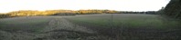
From a vantage point about 100 yards to the right and higher on the hillside, the terrain of the valley can be seen. This is a panoramic picture, made with software that has stitched together three photos. This view includes everything from the northeast around to the south. If it has been a Roman road that has been followed so far, a plausible route down to the river, a plausible crossing site and a plausible route up the other side will need to be identified. The example of the Cander crossing suggests looking for constant-gradient descending and ascending slopes without sharp turns, plus river banks suitable for crossing. The hill seen in the distance (beneath the white cloud) is Tinto Hill, a prominent upper Lanarkshire landmark 12 miles away. There have been suggestions that Tinto was used by the Romans for signalling, however I'm skeptical. I'm not aware of any signaling technology available in Roman times that allowed communications over that distance. |

|
At the edge of the wooded area there is clearly a junction of old roads. The only question is, could any of them be 1800 or 1900 years old? The old maps suggest that there was a road junction at that site in the 1700s. Maps show a road angling down the hillside to a crossing of the River Nethan near where it flows into the Clyde about a half mile south of here. The other road is an entrance driveway that goes from the 1700s north-south road down to the Threepwood Farm. This picture shows the beginning of that driveway. On the left of this picture is a row of trees (beech I believe) that probably were once a field edge hedge. Before wire fencing became available in the later 1800s, dense hedges were grown around fields to contain livestock. After farmers stopped trimming the hedges, they became trees. Beyond the left edge of this picture is a knob of hill sticking out from the main hillside that has the name Lockhart's Knowe. |

|
Continuing down the slope beside the row of trees the route bends around the side of Lockhart's Knowe. The descending gradient is surprisingly constant, compared to the natural hillside off to the right. |
|
Further down the slope there is a row of trees on both sides and the surface is below the level of the land on each side. It looks like a man-made cut to retain the constant descending gradient. One wonders whether it would have been important enough for an eighteenth century farm to invest that much work to ensure that the driveway descended from the road on a constant gradient. Or was the work done by Roman soldiers who weren't pursuing rebelling natives, so they were put to work ensuring that the road could accommodate heavily loaded supply wagons? |

|
The route then turns about 30° to the right, which makes it directly perpendicular to the river, about a quarter of a mile ahead. At this point the River Clyde flows directly north. The picture shows that this portion of the route is currently used for tractor access to the fields as well as a livestock pen. In the distance is the modern Clyde Valley Road. |

|
Directly ahead, across the Clyde Valley Road (also known as Lanark Road and the A72), is the Threepwood Farm sign beside their current driveway. Between the sign post and the railing post one can see a fence in the green field beyond. This photo shows that that fence is perfectly aligned with the route being followed, since it is going directly away from the camera. The trees beyond the green field are on the bank of the river. |

|
This picture was taken on the bank of the River Clyde, looking between trees. The river is currently about 150 feet wide at this point. The bank on the other side is sand -- it is easy to walk to the edge of the water (in the winter when the six-foot weeds are dead). The bank on this side of the river has been built of stone, probably within the last 100 years, to enlarge the field. The 150-year-old map shows the river wider at this point. It seems likely that there was a sand bank on this side, like on the other side, particularly since the old map also shows two sand islands several hundred feet downstream along this river bank. If the river was originally wider here it would have been shallower and the water probably didn't flow quite as fast either. So it seems that it would have been a possible fording site when the river wasn't in flood. However, considering the speed that the water is flowing, it doesn't seem like it would have been a very safe fording site except during dry weather. |

|
This photo was snapped at the river bank beside the fence that could mark the route, looking back up at Lochhart's Knowe, in the upper center of the picture. |

|
Having identified a plausible constant gradient route down to the river via the old Threepwood driveway, it seemed wise to follow the other route too. This picture was taken back up at the saddle between Lochhart's Knowe and the main hillside. The line of the eighteenth century road down the hillside heading southeast is clear. |

|
This route has a gently descending slope, with a hedge and drainage stream on the downhill side. On this bright autumn day, the tree ahead that was once part of a roadside hedge is quite colorful. |

|
Just beyond here the visual evidence of the former road disappears into a former mining site. From the old and current maps it appears that the route served as the mine access road after the current Clyde Valley Road was built in the early 1800s. |

|
If this route once led to a river crossing it would have reached the bank on the other side of this field that slopes down to the Clyde. This picture was taken beside the present A72. |

|
The river bank here, and on the other side of the river as well, is stone, not sand as was probably the case about 300 yards downstream. This could have been the site of bridge, though no evidence has been identified on this side of the river. The next place to explore is the large field on the other side of the river, just beyond the riverbank trees. |
|
This is a panoramic view of the flat flood-prone 80-acre field just east of the River Clyde, half a mile north of modern Crossford (and it's old stone one-lane bridge across the Clyde). This view ranges from northeast around to the south. After tracing the routes down to the river on the other side postulated that their could have been two crossings, a ford downstream which was superseded by a bridge upstream of here, an aerial photo of this field was sent to me. The crop marks in the aerial photo show one corner and portions of two sides of a rectangular defensive trench. It is located exactly between the two postulated river crossings, 100 to 200 feet northeast of the camera that took this picture. The aerial photo crop marks also show several swaths of poor soil that might be due to road gravel that has been scattered by modern plowing. The soil was probed at two spots about 200 feet southeast of where this picture was snapped and both showed a solid pattern of bottoming stones. |

|
This is a scanned image of the aerial photo that is in the archives of the Royal Commission in Edinburgh. This image is scanned from the paper copy I received, which explains a few water splotches that it suffered when I had it out in the field on a damp day. The original image was submitted to RCAHMS by Professor Hanson but there is no date on it. This view is looking toward the northwest. The flow of the River Clyde on the left half of this picture is due north and then at the center of the picture it bends to the north-northeast. The thin dark line near the center of this picture in the shape of a backward L with a rounded corner was probably one corner and portions of two sides of a defensive trench around a rectangular structure. The trench line looks very similar to those around the Trimontium Roman fort near Melrose, though this is likely to be a far smaller enclosure. Without detailed excavation, one can not say for sure that this was a fortified Roman camp. This picture shows that both ends of the L-shaped trench end at a broad swath of lighter-colored soil. Standing in the field it is easy to see that the ground level becomes lower along that swath, suggesting that river floods washed away the level of the ground leaving a concentration of gravel on the bank. In other words, it appears that the other three corners of the defensive trench have been washed away by the river. In recent centuries low earthen dikes have been built to keep flood water out of the field. In the previous picture, the panoramic view, the low dike that extends straight east from the river is visible. It is also visible near the center of this aerial image. The broad light-colored swath that extends left-to-right in this aerial view (southeast of the L-shaped trench) is where I probed the field and found what seemed to be bottoming stones. Note that the broad swath angling away from the river at about a 45 degree angle ends at the swath parallel to the river where floods had eroded away the soil leaving a gravel bank. Along the right edge of this aerial photo there could be one or two swaths of gravel converging on the only exit from this field, just beyond the lower right corner of this picture. On the far (west) bank of the river, the modern Clyde Valley Road is seen crossing the upper left corner of this picture. The fence line down to the river from Threepwood Farm driveway can be seen in the upper center of this picture. The postulated up-river crossing would have been at or near the lower left edge of this picture. |

|
The two cows in this picture are standing within the defensive rectangle that appears in the aerial photo. On the other side of the field, the dark wooded area on the right is a huge pile of mining waste. The hill behind it, that extends to the center of this picture, is Poplar Hill. It is a steep-sided hill, with a modern house overlooking the 80-acre field. Near the left most house in this picture is the only way out of this field that can be used by a wheeled vehicle. The present-day road between the two houses rises sharply as it goes up Poplar Hill in a way that doesn't look Roman at all. However, there is a gently rising route in that green field near the left house (which is called Poplarglen Cottage). |

|
When one first enters that green field seen in the previous picture, it doesn't look like there could have been a road. The slope down from the left is too steep. But then it was noticed that that slope is mining waste gravel covered with enough soil to support grass for sheep grazing. |

|
From the other side of the mining heap, the natural shape of the valley between Poplar Hill on the right and the main Clyde Valley hillside on the left is evident. It is a gently rising slope drained by a small stream that could have been beside a road in the distant past. |

|
The route up through that small valley is well aligned with the present-day road that continues beyond the gate at the upper end of the field. About 150 yards up that road, a long-radius U-turn could have begun in front of where the second house is today. The U-turn route could have swung from the southeast direction of this photo around for a north-northwest ascent of the hillside. |

|
Half way through that U-turn there is this lane just beyond the house. As can be seen, it continues to bend around to the left to pass behind the barn. |

|
Then there is a constant-gradient ascent up the side of the steep hillside. This track seems to have been in use as recently as the mid-1900s for farm access between upper and lower fields. |

|
This picture was taken near the top of the ascent of the steep wooded hillside. This view is looking slightly west of due north. Ahead is the west edge of the upper field. |

|
In that upper field looking east-northeastward up the less steep remainder of the Clyde Valley hillside, the orange dot in the center is my map. Since this field looked relatively undisturbed, it seemed a promising site to probe for bottoming stones. Centered where the map is located in this picture, a solid pattern of bottoming stones was detected. Then the question became, where did the route go next. Since it had just gotten across a major physical barrier, the Clyde Valley, it seemed that the route may have turned more northward or more eastward. It seemed that the next evidence found would point to the final destination of the route being explored. |
|
But before leaving the upper slope east of the Clyde, this photo was taken looking back into the valley. On the other side of the valley, the old road junction in the saddle between Lockhart's Knowe and the main hillside is at the center of this picture. The route from the hilltop beside the motorway past Draffan Burn comes through that thickly wooded area on the upper slope of the valley. The route of the eighteenth century road is along the lower edge of the woods and slopes down to the houses near the left edge of the picture. The old driveway down to Threepwood Farm is the line of trees that starts down to the right, just this side of Lockhart's Knowe, and then turns toward the cluster of farm buildings visible just above the foreground trees. |

|
This picture was taken from high on the west side of the valley to show the pertinent spots on the floor of the valley and up the east slope. All across the center of the picture, the brown field is the 80-acre field. The river is in the line of trees just this side of the brown field. The steep sides of Poplar Hill, just beyond the brown field, are fairly clear in this picture. The plausible route up the hillside is from the lower green field near the left side of this picture, then behind Poplar Hill, then the U-turn around the houses, then angling up the steep wooded hillside to the upper green field just left of the center of this picture. |

|
About six-tenths of a mile northeast of the bottoming stones detected by probing on the high slope east of the Clyde, bottoming stones were found beneath the grass just before the small stream in this picture. At this site the stream is easy to cross, but less than 100 feet downstream, over my left shoulder as I snapped this photo, this stream falls into a steep-walled ravine. Some of the maps call the stream Maregill Burn. Finding apparent bottoming stones at this site suggests a northeast bearing for the route east of the Clyde. |

|
The next field northeast of Maregill Burn is disturbed by mining or quarrying. But then there is this half-mile-long field boundary hedge that goes along the crest of a minor ridge on a northeast bearing. |

|
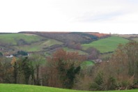
From the top of that minor hill, most of the view ahead is filled with the town of Carluke. The destination of the route now seems to be the ridge on the other side of Carluke, which is visible in the center right of this picture. |
|
Due to the development of modern Carluke, probing the soil for bottoming stones is not a viable search method. So seeking a plausible route is the goal. The major geographical obstacle is Jock's Burn, which flows through the town in a ravine that is typically 70 feet deep. The top edge of the Jock's Burn ravine at this spot is closely aligned with the northeast bearing from the hilltop just outside of town. A turn in the route to an east-northeast bearing points toward the present day walking path. A person in dark clothing can be seen emerging from that path at the center of this picture. |

|
Coming up the path are young people walking home from high school. |

|
The slope of the path is a constant gradient, consistent with the other slopes along the route explored. The present-day footbridge across Jock's Burn is seen ahead. |

|
The current bridge seems to be built on concrete piers of an early 1900s single-lane car bridge. If this was an ancient crossing, it seems like the original alignment would have been slightly to the right of the current bridge, in the direction the camera is pointing. |

|
Up the other side of Jock's Burn there is a gentle slope back onto a northeast bearing. There has been a road here but today it is a walking path. The old maps show a small stream that is today beneath the ground in a pipe. |

|
Here the straight gradual up-slope is continuing on a northeast bearing. The house ahead faces onto Carnwath Road, currently the major highway to the southeast. |

|
On the vacant land behind the buildings along Carnwath Road, I hoped to find evidence of bottoming stones. But consistent evidence was not found. Looking more carefully, it became clear that the ground had been considerably disturbed. There could have been some quarrying or mining. The 150-year-old map shows a mine immediately across the street on the left. Beyond the fence are high school sports fields. |

|
Since this area was walked for the reports submitted to Scottish Archeologists, the old high school building has been demolished and replaced by these sports fields. If there had been any evidence of Roman bottoming stones, it is certainly gone now. This photo was taken in September 2008, a year and a half after the other pictures. |

|
About 100 feet beyond the soccer fields, it appears that the route turned east-northeast along this road, which was seemingly built in the early 1800s. Prior to that, Carluke wasn't a town. Before quarrying and mining made Carluke into a town, the main road from Motherwell and Wishaw to the southeast was the old Roman route along the ridge. It seems that the road shown in this picture connected the ridge-top main road with the emerging town of Carluke. It seems possible that this early nineteenth century road was built on the route of the possible Roman road followed in this study. |

|
Near the upper end of the old road from Carluke, it passes between large piles of tree-covered mining waste on each side. From the late 1700s, numerous areas of Lanarkshire were supplying raw materials for the emerging heavy industry of Glasgow. There was a lot of coal taken from surface quarrying and shallow mines. Iron ore (the old books call it ironstone) was quarried for the foundries and steel mills of Glasgow and North Lanarkshire. And limestone was quarried and baked in kilns to make lime, which was used in cement and to improve the productivity of the peaty (acidic) soil of area farms. |

|
At the top of the waste heaps the route turns due east. It isn't real clear in this picture but the foreground farm road is perfectly straight on a precisely west-to-east alignment with the road barely discernable beyond the trees. Like the high school soccer field picture, this picture and the four that follow were snapped in September 2008 when things were more green. |

|
That's the road that has been documented as Roman for at least 250 years. This is the Roman road from Carstairs (southeast of here) to Motherwell (northwest of here) and on toward the Antonine Wall beyond that. At the moment of this picture, the 1900-year-old road was being used by a Sunday afternoon cyclist. About 100 feet ahead of where this photo was snapped, the route reaches it's highest point. |

|
The level highest point of the road is about 100 feet long. It is interesting that this straight east-west road is at the highest spot within miles (one can see the hills on the other side of Glasgow from here). One wonders if the Romans had a small fort at this location. If so, there isn't likely to be much surviving evidence since there has been extensive quarrying and mining on both sides of this road. The reports that I submitted to Scottish archeologists refer to this spot as Hillhead because that is the name of the farm just beyond the mining south of here. |

|
This view shows the Roman road starting a gentle down-slope and at the same time it is gently bending toward the southeast. It goes east-west only for a short distance behind where this picture was taken. |

|
This is the view from the same road, in this case looking straight west. The road bending off to the northwest is a Roman route. Beyond what is visible in this picture, today's road then bends left, while the original Roman route continued straight northwest until it crossed Belstane Burn and then seems to bend more northward. It is speculated that the Roman destination for that route could have been the central portion of the Antonine Wall, possibly at Castlecary. In the center of this picture a lane can be seen going into the wooded area, continuing the bearing straight west. That's the muddy farm track seen four pictures back. About 100 yards down that lane the route up from Carluke emerges from between the two piles of mine waste. My speculation is that there was another Roman route. It continued straight west from here for about a mile and then turned northwest to roughly follow the Old Wishaw Road, and beyond the Garrion Burn following the long-accepted Roman route through Wishaw and Motherwell. It seems like such a route would have saved the Romans the work of building a road across the boggy land of upper Garrion Burn. |

|
That is the end of the pictures of the eight-mile connection route that has been explored between the long-known Roman route south of Stonehouse to the long-known Roman route east of Carluke. If you would like to see the written reports and maps of the route explored, click the following link: Roman road reports The sign in this picture isn't along the route explored. But I've thrown the picture in here anyway. About ten miles to the northwest, in the modern town of Motherwell, there is a residential street called Roman Road. It is an accurate designation, since it is along the line of the Roman road from their fort near Carstairs to their Bothwellhaugh fort just beyond Motherwell. The street sign on the side of a house was photographed on a day when there was blue sky. And by the way, the "Roman Road" image used on the web site home page is a photo of a street sign in the center of the northwest Glasgow suburban town of Bearsden. That street named Roman Road is along the Roman military route immediately behind the defensive wall built by the Romans that crossed Scotland, that is now known as the Antonine Wall. |
Back to Bill's home page
Back to Roman road page